|
Sheridan County Historical Floods
| DAMAGING FLOODS |
| Location | Start Date | Information |
|---|
| Sheridan, Big Goose Creek, Little Goose Creek | 29-Sep-1923 | An overabundance of rain caused flooding resulting in wooden paving blocks washed downstream, flooded basements, and flooded bridges. Also, accumulated debris under bridge caused water backup; amount of damage estimated at $500,000. Powder River at Arvada had a discharge of 100,000 CFS. |
| Sheridan, Little Goose Creek, Big Goose Creek | 3-Jun-1944 | A 15-year flood from an overabundance of rain resulted in flooded basements and bridges. According to WEMA Flood Damage Inventory the Tongue River near Dayton had a discharge of 3,400 CFS and according to FEMA Flood Insurance Study January 19, 2001 it had a discharge of 4,040 CFS. |
| Sheridan, Prairie Dog Creek | 27-Jun-1953 | Heavy rain (3.4 inches in one hour) caused flooding damaging ranches and loss of equipment |
| Sheridan, Big Goose Creek, Little Goose Creek | 1956 | A less than 10-year flood caused by heavy rain flooded basements and destroyed crops and gardens. Discharge amount was 3,360 CFS |
| Sheridan | 15-Jun-1962 | Heavy thundershowers caused flash flooding in Sheridan area. |
| Sheridan | 29-Jun-1962 | Flash flooding from heavy rains occurred in Sheridan area. |
| Arvada | 12-Jul-1962 | Heavy rains on both afternoons caused flash flooding with damage to crops, reservoirs and roads in the Arvada vicinity. |
| Sheridan, Goose Creek, Clear Creek | 15-Jun-1963 | Heavy rains combined with snowmelt runoff, including a storm sewer backing up, caused flooding, resulting in damage of basements and US Army Corps of Engineers Flood Protection project damaged. There was 1 death in Sheridan according to the Wyoming Floods and Droughts, National Weather Summary 1988-90. The following are discharge values from WEMA Storm Data: South Piney Creek near Story (June 15) - 2,090 CFS, North Piney Creek near Story (June 15) - 1,820 CFS, Piney Creek at Ucross (June 16) - 3,570 CFS, East Goose Creek near Big Horn (June 16) - 1,230 CFS, Middle Fork Powder River near Barnum (June 16) - 7,110 CFS, Largest recorded at Sheridan Gauge (June 16) - 5,450 CFS. According to WEMA Storm Data and Flood Damage Inventory it was a 45-year flood and according to Wyoming Floods and Droughts, National Weather Summary 1988-90 it was a 20 to greater than 100-year flood. |
| Wind River, Absaroka, Big Horn Mountains | 15-Jun-1963 | Heavy rains in the Wind River, Absaroka, and Big Horn Mountains caused flash flooding during Saturday and Sunday, the 15th and 16th. Considerable damage done to homes, equipment, crops, irrigation canals, roads and bridges. |
| Sheridan | 20-Jun-1975 | Heaviest rainfall was in the city of Sheridan. 2.51 inches of rain - the second greatest 24-hour amount recorded for June - fell at the Sheridan Airport between 11:00 p.m. on the 20th and 1100 MST on the 21st. Many basements were flooded in the city of Sheridan. |
| Central and North portions of Wyoming | 15-May-1978 | Heavy wet snow and record rains did very extensive damage to property, crops, and livestock in 12 counties. Hundreds of homes were damaged, and many totally destroyed. Numerous bridges and sections of roads were washed out, power lines downed, with much damage to cars and personal property. Total estimated damages came to $15.5 million. The following are discharge amounts from WEMA Storm Data: Fifteenmile Creek near Worland (May 18) - 4,270 CFS, Big Horn River at Worland (May 19) - 17,500 CFS, Nowood River near Ten Sleep (May 19) - 3,380 CFS, Shoshone River near Lovell (May 18) - 7,680 CFS), Elk Creek near Basin (May 19) - 2,450 CFS, Shell Creek near Greybull (May 19) - 2,150 CFS, Big Horn River near Kane (May 20) - 20,700 CFS, Little Powder River below Corral Creek near Weston (May 18) - 2,410 CFS, Little Powder River above Dry Creek near Weston (May 19) - 4,460 CFS, Little Powder River above Dry Creek near Weston (May 19) - 5,300 CFS, Salt Creek near Sussex (May 18) - 10,200 CFS, Dead Horse Creek near Buffalo (May 18) - 1,420 CFS, Clear Creek below Rock Creek 162? CFS, Powder River near Kaycee (May 18) - 4,200 CFS, Powder River at Sussex (May 19) - 24,000 CFS, South Fork River near Kaycee (May 20) - 8,200 CFS, Bitter Creek near Garland (May 17) - 552 CFS, Whistle Creek near Garland (May 18) - 2,340 CFS, Shoshone River below Buffalo Bill Reservoir (May 19) - 1,230 CFS, Shoshone River near Garland (May 19) - 4,550 CFS, Goose Creek below Sheridan (May 18) - 5,430 CFS, Prairie Dog Creek near Acme (May 19) - 3,940 CFS, Clear Creek at Ucross 1740 (May 19) - 32,500 CFS, Crazy Woman Creek at Upper Station (May 20) - 2,200 CFS, Little Thunder Creek near Hampshire (May 18) - 3,030 CFS, Black Thunder Creek near Hampshire (May 18) - 5,050 CFS, Turner Creek near Osage (May 18) - 2,480 CFS, Beaver Creek near Newcastle (May 19) - 3,870 CFS. The event was estimated to be a 20- to greater than 100-year flood |
| Clearmont to Leiter | 29-Jul-1985 | Very heavy rain from storms caused flooding along Clear Creek from Clearmont to Leiter. Some irrigation equipment was damaged. |
| Sheridan, Goose Creek | 24-Feb-1986 | A 300-foot ice jam along Goose Creek, near Sheridan, blocked the creek, causing water to spill over the banks and into a mobile home park. Two hundred and fifty people were evacuated from the Woodland Park Village Mobile Homes. |
| Big Horn, Story | 9-May-1995 | A combination of moderate to heavy rain and snow melted from the adjacent Big Horn mountains caused some creeks and streams to over flow their banks. In the town of Big Horn (eight miles south of Sheridan), the Jackson Creek flooded several roads. In Story (16 miles south of Sheridan), the North Piney Creek washed out portions of two roads and closed two other roads due to high water. |
| Big Goose Creek, Little Goose Creek, Piney Creek | 16-Jun-1995 | A combination of snowmelt from the Big Horn Mountains and some rainfall led to flooding along the east side of the mountains in Sheridan County. The Big Goose Creek, the Little Goose Creek, and Piney Creek all overflowed their banks and produced flooding. The Big Horn reservoir and the Park reservoir overflowed and this added to the volume of water that roared down those creeks. Flooding of roads and a few homes was reported in Story (16 miles south of Sheridan). Big Horn (8 miles south of Sheridan), and in the town of Sheridan. Some evacuations were necessary due to the flooding. Sheridan City Park was under water and some farmland in Sheridan County experienced flooding. No injuries or deaths occurred. Damage estimates were not available. |
| Sheridan Foothills | 7-Feb-1996 | Warm temperatures produced flooding in Sheridan County. Some basements were flooded. Some small streams and creeks went over their banks and flooded low lying areas and some streets. |
| 6 NE Sheridan | 19-Aug-1998 | The Little Goose Creek flooded a small subdivision when a slow moving thunderstorm produced over 1.50 inches of rainfall in 20 minutes. A house basement was reported to have been flooded. |
| Sheridan | 21-Aug-2002 | Business owners reported flooded basements downtown. |
| Sheridan Foothills | 7-May-2005 | Early Creek and irrigation ditches flooded near Ranchester, as well as, basements flooded in Ranchester. |
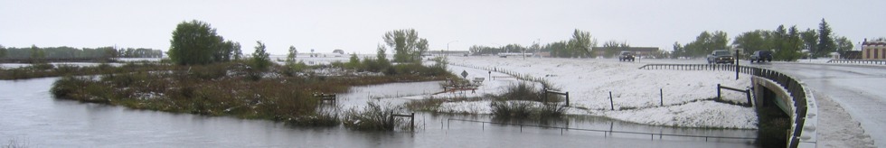
| Sheridan Foothills | 11-May-2005 | Bridge washed out 25ESE Sheridan on County Road 161 west of Ulm; Big Goose Creek flooded out of its banks; massive flooding occurred 5S Sheridan on U.S. Highway 87 between Sheridan and Big Horn. Water was up to many homes in this area; Water up to car doors at the 2000 block of Main Street; Long Drive in Sheridan was under four feet of water near the hospital. Numerous cars were stalled in the high water. |
| NON-DAMAGING FLOODS |
| Sheridan | 15-Jun-1996 | Flash flooding was observed in Sheridan, Wyoming. However, the waters subsided quickly. No known damages. |
| 11 NE Sheridan | 14-Jul-2001 | Minor flooding over roads…hail floating on water. |
| Sheridan Foothills | 8-May-2005 | Water ran across 5th avenue on the west side of town. Water also filled parking lots. |
| 1 W Pinedale | 27-Jun-2004 | Flash Flood |
|