Map Modernization Overview and Introduction
The Federal Emergency Management Agency's (FEMA) Flood Hazard Map Modernization Program (Map Mod) is an ambitious multi-year effort with the goal of modernizing flood insurance rate maps (FIRMs) nationwide.
The map modernization program will upgrade the 100,000 panel flood map national inventory into seamless flood data publicly available in geographic information system (GIS) format. The product of the FEMA map modernization program will be digital versions of the flood insurance rate maps or digital flood insurance rate maps (DRIFMs) The aggressive schedule necessary to meet the goals of this conversion effort requires the support of local governments.
Goals of the Map Mod Program are:
- Developed up-to-date flood hazard data for all flood prone areas nationwide.
- Provide digital flood maps and data in an industry-standard GIS format to improve the efficiency and precision for use by mapping program customers.
- Fully integrate FEMA's Local, Regional, and State government partners into the mapping process to build on their local knowledge and data development efforts.
Why Modernize
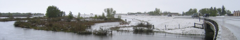
Flood map modernization is essential for preparing communities for flood disasters. Currently over 85% of the Nation's flood insurance rate maps (FIRMs) are over 5 years old. FIRMs are paper maps that were created using obsolete cartographic methods and are used for flood hazard mitigation throughout the nation. FIRMs are estimated to be used 15-20 million times annually for: Mandatory Purchase Determinations, Flood Insurance Rating, Flood Management, and Emergency Management Purposes. Many FIRMs in Wyoming are considered to be outdated and inaccurate. FIRMs are essential for floodplain management in community planning efforts as well as for homeowners residing in flood prone areas.
The need to modernize is clear, with growth and development, communities are at risk of experiencing flooding and possible loss of life. The new modern digital flood insurance rate maps (DFIRMs) will be more closely aligned with actual flooding risks, encourage and permit wise floodplain management, and increase the public's flood hazard awareness.
The Making of Digital Flood Insurance Rate Maps (DFIRMs)
Digital Flood Insurance Rate Maps are created in a Geographic Information Systems (GIS) geodatabase with the most current and high resolution base map layers available. A base map is a map of a community that depicts cultural features (e.g. elevation, roads, railroads, bridges, dams, and culverts), drainage features, and corporate limits. Base map features, along with flood hazard information, are all utilized in the creation of the final DFIRMs.
FEMA has set strict guidelines and standards for DFIRMs created through the Map Modernization Program. Guidelines and standards have been created so that a seamless data bank of flood hazard data will be available for use to floodplain managers and communities.
Data submitted to FEMA for inclusion in a DFIRM will be stored in a national database and can be redistributed upon request from localities. The benefits to communities are countless. Here are just a few:
- Less long-term flood damage in the community as a result of insuring properties more accurately
- Access to more reliable floodplain, floodway, Base Flow Elevation data (BFE), cross section, and other data that has been adjusted to the local government's base map
- Ability to overlay/query reliable flood data in relation to other data that the local government may have (example: New aerial photos, updated transportation layer).
Summary
The Map Modernization Program (Map Mod) is $1 billion program administered under FEMA to update the Nation's flood insurance rate maps (FIRMs). As part of the modernization effort, existing FIRMs are being converted to a new map format, termed Digital Flood Insurance Rate Maps (DFIRMs). DFIRMs are delivered in Geographic Information System (GIS) format allowing data to be easily shared. Map Mod funds are allocated on a county basis. The final DFIRM products will be integrated into a seamless national flood hazard geodatabase. DFIRMs will be available to download at the FEMA Map Service Center website. (http://msc.fema.gov/webapp/wcs/stores/servlet/StoreCatalogDisplay?storeId=10001&catalogId=10001&langId=-1&userType=G)
The Map Mod Program will benefit all counties within Wyoming by producing up-dated and more accurate DFIRM maps. A collaborative approach involving local, state, and federal governments is needed to accomplish the work involved in producing the best possible outcome for all involved in the map mod program.
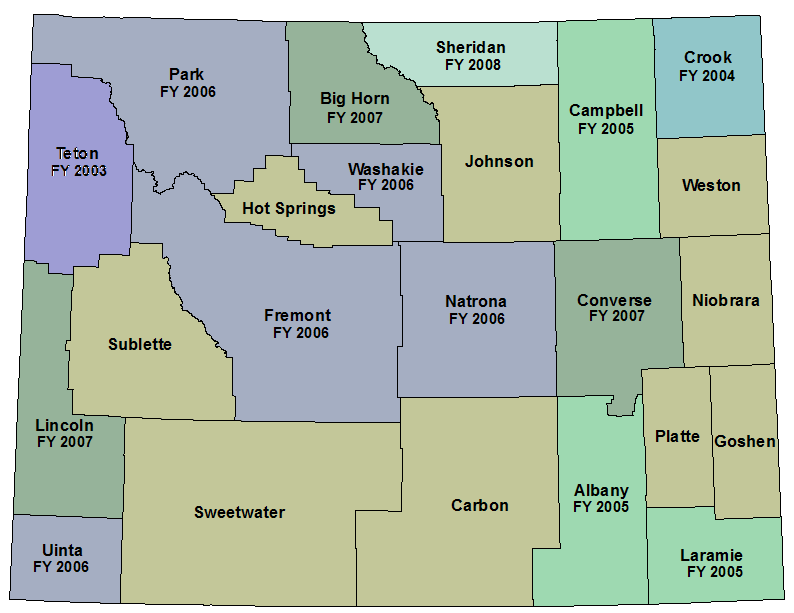
Wyoming Map Modernization Sequencing
(Dates represent year of initial funding)
|