|
Converse County Historical Floods
| DAMAGING FLOODS |
| Location | Start Date | Information |
|---|
| Douglas, Antelope, East Antelope | 1962 | A flood occurred to inadequate bridge capacity and storm sewer overload. Mostly basements and structures with first floor levels were damaged. |
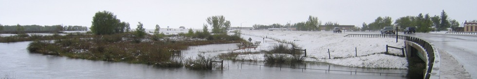
| Glenrock, Deer Creek | 14-May-1965 | Heavy rains, especially in central mountains, on top of heavy snow caused flooding on streams flowing out of Laramie Mountains below Wheatland and Casper. Homes, utilities, park facilities and athletic field, water and sewer services were disrupted, many bridges and culverts destroyed; amount of damage: Glenrock ($50,000), County ( $125,000); especially heavy damage from Glendo through Douglas to Glenrock. The following are discharge values: Box Elder Creek at Box Elder - 4,530 CFS, LaBonte Creek - 8,770 CFS, North Platte River near Glenrock - 16,000 CFS, North Platte River at Orin (May 15) - 23,000 CFS. |
| Bill | 16-Jun-1965 | Flash flood killed one coal miner on Antelope Creek. |
| Glenrock, Deer Creek | 12-Jun-1970 | NE residential area flooded, municipal park severely damaged, trailer court, croplands, bridges, fences and farm buildings damaged, amount of damage: $1 million. The following are discharge amounts: Deer Creek at Glenrock - 14,200 CFS, LaPrele Creek near Douglas - 17,300 CFS |
| Laramie Range drainage, eastward southwest of Douglas near LaPrele Reservoir | 22-Jul-1983 | Heavy Thunderstorms sat almost stationary on E slopes of Laramie Range for hours. Caused widespread flooding along creeks & streams, runoff collapsed the dam sending a10- to15-foot high wall of water thru nearby ranch, flooding it. |
| Glenrock | 1-Aug-1984 | Thunderstorm dumped two inches of rain in 30 minutes, or 3.2 inches total from 1.5-hour deluge at Glenrock in Converse County. Rain flooded basements of several houses, a car and several businesses. Other minor damage due to flooding and lightning strikes. |
| 50 NW Douglas to 30 N Douglas | 1-Jul-1998 | A storm produced up to 6 inches of rainfall from 50 miles northwest of Douglas to 30 miles north of Douglas. Water covered many rural roads in the area. |
| Central Wyoming | 13-May-1965 | Heavy rains, especially in the central mountains, on top of the heavy snow of the 8th and 9th caused flash flooding on streams flowing out of the Laramie mountains between Wheatland and Casper. Damage to Bridges, roads, crops and housing was especially heavy from Glendo through Douglas to Glenrock. |
| Southeast Wyoming | 10-Jun-1970 | Heavy rains up to 6 inches in the Laramie Mountains from Casper to Wheatland caused flooding on the tributaries of the North Platte River. Some of the moisture fell as snow above 7500 feet elevation. |
| Central and North portions of Wyoming | 15-May-1978 | Heavy wet snow and record rains did very extensive damage to property, crops, and livestock in 12 counties. Hundreds of homes were damaged, and many totally destroyed. Numerous bridges and sections of roads were washed out, power lines downed, with much damage to cars and personal property. Total estimated damages came to $15.5 million. The following are discharge amounts from WEMA Storm Data: Fifteenmile Creek near Worland (May 18) - 4,270 CFS, Big Horn River at Worland (May 19) - 17,500 CFS, Nowood River near Ten Sleep (May 19) - 3,380 CFS, Shoshone River near Lovell (May 18) - 7,680 CFS), Elk Creek near Basin (May 19) - 2,450 CFS, Shell Creek near Greybull (May 19) - 2,150 CFS, Big Horn River near Kane (May 20) - 20,700 CFS, Little Powder River below Corral Creek near Weston (May 18) - 2,410 CFS, Little Powder River above Dry Creek near Weston (May 19) - 4,460 CFS, Little Powder River above Dry Creek near Weston (May 19) - 5,300 CFS, Salt Creek near Sussex (May 18) - 10,200 CFS, Dead Horse Creek near Buffalo (May 18) - 1,420 CFS, Clear Creek below Rock Creek 162? CFS, Powder River near Kaycee (May 18) - 4,200 CFS, Powder River at Sussex (May 19) - 24,000 CFS, South Fork River near Kaycee (May 20) - 8,200 CFS, Bitter Creek near Garland (May 17) - 552 CFS, Whistle Creek near Garland (May 18) - 2,340 CFS, Shoshone River below Buffalo Bill Reservoir (May 19) - 1,230 CFS, Shoshone River near Garland (May 19) - 4,550 CFS, Goose Creek below Sheridan (May 18) - 5,430 CFS, Prairie Dog Creek near Acme (May 19) - 3,940 CFS, Clear Creek at Ucross 1740 (May 19) - 32,500 CFS, Crazy Woman Creek at Upper Station (May 20) - 2,200 CFS, Little Thunder Creek near Hampshire (May 18) - 3,030 CFS, Black Thunder Creek near Hampshire (May 18) - 5,050 CFS, Turner Creek near Osage (May 18) - 2,480 CFS, Beaver Creek near Newcastle (May 19) - 3,870 CFS. The event was estimated to be a 20- to greater than 100-year flood |
|