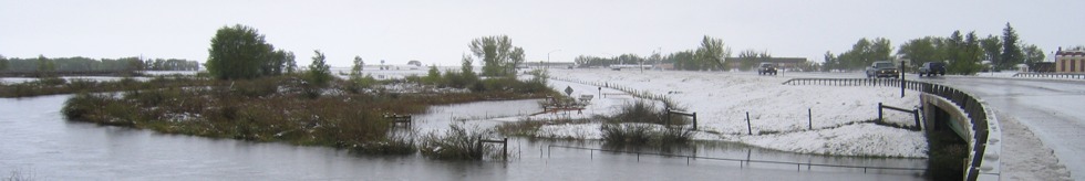
| DAMAGING FLOODS |
| Location | Start Date | Information |
|---|
| North Platte River, Tributaries near Saratoga, tributaries near Little Snake River | 12-May-1984 | Rain storms combined with snowmelt runoff augmented on Little Snake River when water breached a dam. Damage to rural property in Baggs. Greater than 100-year flood |
| Baggs, Savery, Dixon, Little Snake River | 14-May-1984 | High runoff from melting snow in the mountains of southern Wyoming and northern Colorado; Burst small dam, 4-foot wall of water poured down canyon (sudden warm temps & heavy blanket of snow). $5 million of damage to area; damage to water treatment plant, land crops, fences, irrigation systems, structures, livestock, 26 homes and trailers damaged. Recovery response was from small business administration, Civil Defense, Red Cross, and Army Corps of Engineers. Runoff estimated at 500-year level. |
| Dixon | 16-May-1984 | A greater than 100-year flood caused by snowmelt runoff augmented by an upstream reservoir failure had a discharge of 13,000 CFS. |
| Near Saratoga | 11-Aug-1990 | Heavy thunderstorm rains of 1- to 3-inches caused flash flooding mainly in the Snowy Range 15 to 20 miles east of Saratoga. Two campgrounds in the Snowy Range had to be evacuated due to high water on creeks and streams. |
| Rawlins | 24-May-1996 | Heavy rainfall in a short time caused street flooding in Rawlins. Some roads were closed for a time and some accidents occurred. |
| 35NW Laramie | 10-Jun-1986 | Pierce Dam failed at 1941 MST, spilling its contents into Rock Creek. This was about 35 miles northwest of Laramie along the Albany and Carbon County line. A bridge over Rock Creek along Wyoming Highway 13 was undercut. There was some flooding of buildings and ranch lands where Rock Creek runs into the Medicine Bow River. |