| DAMAGING FLOODS |
| Location | Start Date | Information |
|---|
| Spring Creek | 8-May-1905 | Overflowing of the Creek caused by thunderstorms occurring throughout the watershed during the spring and summer resulted in flood damaging property and interrupting transportation due to roads being washed out. |
| Laramie River |
12-Jun-1923 |
Snowmelt probably combined with rainfall runoff resulted in a flood 25- to a greater than 100-year flood. |
| Northern Albany County, Ashley, Hall, Rock Creek, Spring Creek | 29-Jul-1953 | Cloudburst caused a flash flood down canyon where there was damage to roads, ranches, out buildings, fences, haystacks, corrals, and machinery. There was $1800 total damages to national forest: Roads ($1000), Meadows ($500), and Springs ($300); Major thoroughfare over $30,000, loss of livestock: cows, calves, and horses. Pioneer residents remembered this as the heaviest rain ever. |
| Laramie | 29-Jul-1953 | Flood caused by a cloudburst and backed up storm sewers (hardest hit area Canby, Gibbon & 9th Streets). Dirt streets were washed away and caved in from downpour. The event produced 0.88 inches of water in 45 minutes. |
| Laramie, Laramie River | 9-Jun-1957 | Flooding from Late spring, slow melt then high temperatures with falling rain channel not kept clear because of drought years; silt deposited and debris collected. This caused quarries to be flooded; bridges, culverts washed out, flooding of homes (west Sheridan); ranch buildings damaged; families evacuated. This was a greater than 50-year flood that had a discharge of 3,800 cubic-feet-per-second (CFS) at Pioneer Dam (25 miles southwest of Laramie) according to WEMA, Laramie Boomerang, Flood Damage Inventory. Federal Emergency Management Agency (FEMA) Flood Insurance Study October 16, 1996 set the discharge amount to 3,250 CFS. |
| Central Wyoming | 13-May-1965 | Heavy rains, especially in the central mountains, on top of the heavy snow of the 8th and 9th caused flash flooding on streams flowing out of the Laramie mountains between Wheatland and Casper. Damage to Bridges, roads, crops and housing was especially heavy from Glendo through Douglas to Glenrock. |
| Southeast Wyoming | 10-Jun-1970 | Heavy rains up to 6 inches in the Laramie Mountains from Casper to Wheatland caused flooding on the tributaries of the North Platte River. Some of the moisture fell as snow above 7500 feet elevation. |
| Laramie | 23-Jul-1984 | Flash flooding from a late evening thunderstorm in east Laramie did thousands of dollars damage to residences and businesses (NCDC Storm Data). 100-year storm produced 1.04 inches of water in less than 24 hours. Wall of water breached dike, storm sewer overload. Damage to residences and businesses estimated to be thousands of dollars. University of Wyoming damage estimated to be $100,000. Wyoming School of Gymnastics estimated to be $12,000. Five percent of Laramie homes damaged. Flood channel damaged with erosion to bridges. |
| Laramie | 15-Aug-1984 | Thunderstorm dumped up to 1.67 inches of rain in an hour-long deluge across Laramie in Albany County. Damage to basements of houses, cars, and a just-completed flood channel. |
| Laramie | 19-Jul-1985 | Storms dumped up to 1.26 inches of rain in Laramie, causing minor urban flooding. Two unconfirmed funnel clouds were also reported. One was west, and the other southwest, of Laramie at a distance of about 10 miles. |
| 35NW Laramie | 10-Jun-1986 | Pierce Dam failed at 1941 MST, spilling its contents into Rock Creek. This was about 35 miles northwest of Laramie along the Albany and Carbon County line. A bridge over Rock Creek along Wyoming Highway 13 was undercut. There was some flooding of buildings and ranch lands where Rock Creek runs into the Medicine Bow River. |
| 25 SW Wheatland | 20-Aug-1990 | A small but intense thunderstorm dumped up to 4 inches of rain and small hail just east of the Sybille Research Center. Water filled normally dry creeks, with Wyoming Highway 34 covered with up to 4 to 5 feet of water in some spots. Some bridges and corrals were washed out on ranches. |
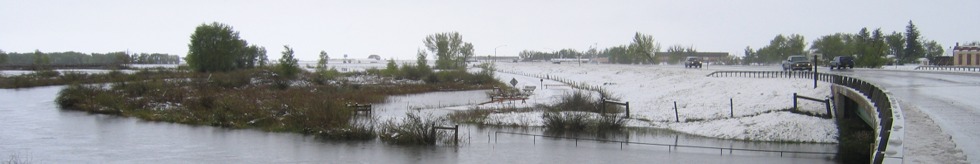
| Laramie Valley - Laramie Range | 04-Jun-2005 | An unusual late season snowfall blanketed parts of southeast Wyoming at elevations generally above 7500 feet. Laramie, WY. Reported 4-6 inches of snowfall which damaged many trees. 12 inches of snow was reported over the southern Laramie Range which forced the closure of Interstate 80 for several hours. |
| NON-DAMAGING FLOODS |
| Centennial | 1991-07-25 | Centennial received 0.75 inch of rain in a short period of time that caused minor flooding with little, if any damage. |